


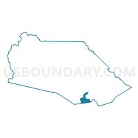
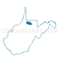
Voting District 39, Marion County, West Virginia
About
Outline

Summary
| Unique Area Identifier | 691185 |
| Name | Voting District 39 |
| County | Marion County |
| State | West Virginia |
| Area (square miles) | 2.95 |
| Land Area (square miles) | 2.89 |
| Water Area (square miles) | 0.06 |
| % of Land Area | 97.83 |
| % of Water Area | 2.17 |
| Latitude of the Internal Point | 39.40604250 |
| Longtitude of the Internal Point | -80.14656470 |
Maps

Graphs
Select a template below for downloading or customizing gragh for Voting District 39, Marion County, West Virginia


Neighbors
Neighoring Voting District (by Name) Neighboring Voting District on the Map
- Voting District 114, Marion County, WV
- Voting District 115, Marion County, WV
- Voting District 2, Taylor County, WV
- Voting District 3, Taylor County, WV
- Voting District 38, Marion County, WV
- Voting District 40, Marion County, WV
Top 10 Neighboring County Subdivision (by Population) Neighboring County Subdivision on the Map
Top 10 Neighboring Unified School District (by Population) Neighboring Unified School District on the Map
Top 10 Neighboring State Legislative District Lower Chamber (by Population) Neighboring State Legislative District Lower Chamber on the Map
- State House District 41, WV (71,101)
- State House District 43, WV (56,711)
- State House District 42, WV (19,954)
Top 10 Neighboring State Legislative District Upper Chamber (by Population) Neighboring State Legislative District Upper Chamber on the Map
Top 10 Neighboring 111th Congressional District (by Population) Neighboring 111th Congressional District on the Map
Top 10 Neighboring Census Tract (by Population) Neighboring Census Tract on the Map
- Census Tract 212, Marion County, WV (5,433)
- Census Tract 210, Marion County, WV (5,275)
- Census Tract 9647, Taylor County, WV (4,490)